Thursday, September 29, 2022

We're not judging anyone but.... Stuff we saw on the docks before Hurricane Ian

The docks have been abuzz as crews prepare for Hurricane Ian.  It's looking like we'll be getting some rain and wind (but nothing crazy).  Fulmar is all set so we headed out for a dock walk.  We love checking out other boats.  

Preparing for a storm is never fun, but after going through over 30 of them, we've learned some lessons.  So yeah, we indeed judge people when we check out their storm prep.  For your entertainment, here's some of what we saw, annotated with our opinions:

👎👎

Using too few lines.  This is probably a half million dollar boat and they apparently ran out of money for dock lines.  Three lines hold this to the finger dock, which will be the upwind side of this storm.  
Do better.

👍👍

Running lines to the cleats on the other side of the dock.  Dock lines love to have room to stretch and this gives them the space they need.  As long as your dock neighbor is good with it, this is a great way to prep for a storm.  Notice both boats have 2 sets of spring lines -- these are the lines that truly hold your boat in place.   A+.

👍👍

This one wins the award for innovation.  They've run a chain under the dock and each boat is using it as a fourth attachment point.  Bonus points for this idea!


👍👎

Doubling up lines, but they are using a single line for this.  Better than nothing but if that line chafes at the dock cleat (which is likely, given how it is tied), both of these lines are useless.  If you're going to double up, use two separate lines.


👍👍

Using two separate dock lines to double up.  This is the preferable way to add strength.

👍👍

Keeping people safe by adding rags to make it easier to see the lines running across the dock.  
Great idea and these are good neighbors.


👍👍

Tying a line to the bow eye.  If your boat has one of these, it's probably the strongest attachment point you've got.  And running a line from this bow eye keeps the force pulling on the dock cleat down low.  Cleats are not designed to have the line pull upwards; that's how you rip a cleat out of the dock.    
Good move on this crew's part.


👎👎

Running lines that are vertical to the cleat.  This allows the boat to pull up on the dock cleat -- a great way to pull it out of the dock.  Instead use spring lines.


👎👎

Tying boats together.  This video was taken in a light breeze and look at the load as these boats spring back together.  We don't like it.


👍👎

Expensive overkill?  Probably.  Also no chafing gear on the blue line.  Yuck.


👍👎

Using a ratchet strap to secure a dinghy.  Janet says this is fine but Damon is all judgy and says it's not seamanlike.....  (He also says ratchet straps rust and become nasty.  You can accomplish the same thing using any piece of line if you tie a trucker's hitch)


👍👎

Taping over every hatch seam.  Any self-respecting hurricane would laugh at your masking tape.  Can't hurt but probably won't help.


👍👎

Launching the dinghy and filling it with water.  This is a good way to keep your dinghy from flying away.  Just make sure it's safely tied and you pull it out of the water before nasties can grow on the bottom.


👍👍

The king of all fenders. It scared Loki.

👍👍

Lots of fenders (that's our boat, and too much is never enough).


👎👎

Fenders don't do any good unless you deploy them. 


👍👍

Chafing gear.  Love it.


👎👎

Chafed dock line.  Check all your lines regularly and add chafing protection.  This is scary.

👍👎

If your anchor blows away you've got bigger troubles!  But no harm no foul. Unless, things go sideways and you need to deploy that anchor in a hurry.


👍👎

Wrapping the jib sheets around the jib to try to prevent the wind from unfurling it.  Better than nothing but seriously people, take that genoa down.  If there's one thing we do, we take the genny down.  Number one.  


Monday, September 26, 2022

Hurricane Ian

The National Hurricane Center's forecast track and watches & warnings for Hurricane Ian, as of 8:00 PM on September 26.

"Efforts to protect life and property should be rushed to completion.”  

We've been on the receiving end of this warning many times.  It’s the statement the National Hurricane Center issues when hurricane conditions are expected within 24 hours.  We’ve been through dozens of named storms (we lost count in the mid-30s).  We've been lucky, and we've also learned how to prepare for large storms.  Most of the time, the storm turns out to be a near miss.  But you have to be prepared; the tiniest change in the storm's track can mean the difference between a breezy day and catastrophic destruction.  

Hurricane Charley's forecast track and the path it actually took in 2004.   

Sometimes, these storms stagger around like a drunken sailor after last call. Hurricane Charley in 2004 was one such storm.  At the time, we worked for the Sarasota Dolphin Research Program (SDRP) at Mote Marine Laboratory in Florida.  Charley was supposed to make landfall on Anna Maria Island, just a few miles north of Sarasota.  This was a worst-case scenario for us because that path would put us in the eyewall, on the right-hand side of the storm, which usually packs the strongest winds and the greatest storm surge flooding.  But when it got about 30 miles south of us, Charley wobbled drunkenly to the right, unexpectedly making landfall on Cayo Costa (near Ft. Myers) as a category 4 hurricane.  In Sarasota, we barely reached tropical storm conditions.  It felt like we had dodged a bullet.  The people down around Ft. Myers and Charlotte Harbor paid for our good fortune. 

Enhanced infrared satellite image of Hurricane Charley near landfall.


We're thinking about this now because Hurricane Ian is currently forecast to follow a track that is very similar to Charley's forecast track.  Ian is supposed to make landfall just north of Sarasota.  It's a larger storm, moving more slowly than Charley.  This is a bad thing; it likely means greater storm surge.  We're worried for our friends and colleagues at SDRP and at the Sarasota Sailing Squadron, where we kept our previous sailboat.  We know what everyone there is going through: hauling boats out of the water, removing canvas, stowing equipment, trailering small boats to inland locations, securing buildings, safeguarding computers, backing up data, etc., etc.  It is exhausting, stressful work, which always takes place in hot, humid weather, with thunderstorms that grow in frequency and intensity.  It takes 2 or 3 solid days of work to prep for these storms.  SDRP and the Sailing Squadron have very detailed hurricane plans to make sure everything gets done efficiently and nothing is forgotten.  Getting it done quickly is important because everyone also has to safeguard their homes and families.  They've all been through it many times before.  But this one could be different; this one may be really bad for Florida's West Coast.  


This is Hurricane Ian tonight, as we write this. It doesn't look very impressive in this image but by tomorrow morning, it is expected to intensify into a major hurricane.


A closeup of Ian's projected track and the predicted storm surge.  Around Sarasota Bay, the predictions are for 8-9 feet of surge.  Predictions for the northern parts of Tampa Bay exceed 10 feet.  This would be catastrophic, if it comes true.  

Here on the Georgia Coast, Ian may bring low-grade tropical storm conditions and some coastal flooding, but nothing like what they are expecting around Tampa and Sarasota.  We've taken actions to prepare but we're preoccupied with what is going to happen in Florida.  We know the people on the Gulf Coast are paying for our good fortune.  Looking at the satellite images from afar, is like watching a highway accident in slow motion.  If you have any extra good karma, send it to Florida.  They’re going to need it over the next few days.


Monday, September 19, 2022

The World Is Your Oyster

Small intertidal oyster reef (By Jud McCranie - Own work, CC BY-SA 4.0, https://commons.wikimedia.org/w/index.php?curid=114954020)

Eastern oysters, Crassostrea virginica, are bivalve mollusks related to clams, mussels, and scallops. They inhabit brackish estuaries throughout the Atlantic and Gulf of Mexico coasts. Oysters grow together and form large reefs. In the warmer parts of their range, they tend to be found in the intertidal zone. Freezing temperatures can kill them, so in the colder parts of their range, they are subtidal. These unassuming creatures are vital to healthy estuarine ecosystems but also have a dark side. We'll explore both the good and the bad of oysters.

Seven Reasons Why Oysters Rock


1. The oyster is a keystone species. Removing oysters drastically alters the estuarine ecosystem.


A beach on Sapelo Island comprised of oyster shells. Waves and tidal currents remove the shells of dead oysters from the reef and then pile them up on the shore. Without the oysters, this shore would be a marsh bank.

Horseshoe crabs spawning on an oyster shell beach.  The female (larger animal on the left) deposits her eggs in the shell hash and the male (right) fertilizes them. 
2. Oysters are ecosystem engineers. Oysters rock because they make giant, rock-like structures.  They create habitats, known as oyster reefs, that wouldn't otherwise exist.  The three-dimensional structure of an oyster reef is full of nooks and crannies. That means an oyster reef is great habitat for crabs, fishes, snails, worms, and seaweeds.  The oyster pea crab, Zaops ostreum, actually lives within the oyster's mantle cavity, inside its shell.  The oyster is their entire world! 

Oyster larvae are free-swimming plankton. Plankton don't just settle anywhere. They're picky. Oyster larvae prefer to settle and grow on the shells of older oysters.  Once a larval oyster settles, it cements itself in place and spends the rest of its life in that location.  From New Jersey to northern Florida and along the northern coast of the Gulf of Mexico, oysters are the only natural source of hard substrate in estuaries As boaters who frequent coastal waterways in this region, we have mixed feelings about all these hard objects in the water!


Intertidal oyster reef in Doboy Sound, GA.  It's a solid, complex structure rising above the soft mudflat.  These reefs provide habitat for over 300 other species and alter the flow of water through the estuary. 


Oysters growing on a piling.  Notice the ribbed mussels (Geukensia demissa) growing among the oysters.


An individual "wild" oyster taken from a reef.  Note the elongate shape.

3. They clarify the water.  Oysters draw water in and filter microscopic phytoplankton with their gills.  By removing phytoplankton and other small particles from the water, they improve water clarity. Clearer water promotes the growth of seagrass by allowing sunlight to penetrate to greater depths. An oyster can filter about 50 gallons of water per day. At one time, the entire volume of the Chesapeake Bay was filtered in just 4 days by the oysters there. Oyster biomass has declined in the Bay because of over-harvesting, habitat destruction, pollution, and disease. The remaining oysters now take over a year to filter the same amount of water. 

4. They take excess nitrogen out of the water.  Nitrogen is an essential nutrient needed by plants and phytoplankton. But too much of a good thing can cause problems, such as harmful algal blooms like red tide. Excess nitrogen often comes from runoff from farms and cities, inadequately treated sewage effluent, and leakage from aging/inadequate septic tanks.  Oysters help to "denitrify" the water when they filter feed. In addition to filtering edible phytoplankton from the water, they also remove other nitrogen-containing particles. But rather than eating them, they pack these inedible particles together and release them as pseudofeces, which sinks to the bottom and becomes part of the sediment (AKA, mud).
Being in the muck means that this nitrogen is no longer available for phytoplankton drifting around in the water.

5. They stabilize the shoreline, reduce erosion, and reduce the amount of suspended sediment in the water.  Large oyster reefs stand firm against the forces of waves and currents. Oyster reefs break the waves before they get to the shore and they help hold sediment in place.  Larval oysters' preference for settling on the shells of other oysters usually results in them settling onto already-existing reefs.  People can help create new reefs by simply placing recycled oyster shells in the estuary. After a few years, newly-recruited young oysters have cemented themselves to the recycled shells and created a new reef. Because they do such a good job of protecting shorelines, engineered oyster reefs are now used as part of "living shorelines" to prevent coastal erosion.

6. They are protandrus hermaphrodites. Oysters all start out life as male but transition to female when they grow large.  Eggs are energetically expensive to produce, so it helps for females to be large.  And, boy, do they produce a lot of eggs: up to 150 million of them. Oysters are broadcast spawners, releasing eggs and sperm into the water column, where fertilization takes place.   

7. They are delicious, whether you eat them raw, roasted over a wood fire, fried and put on a Po' Boy sandwich, or in a stew.  Overharvesting, habitat destruction, water quality degradation, and disease have reduced US oyster biomass by about 88% during the 20th century.  Today, the biomass of oysters in Chesapeake Bay is just 2% of its historical levels.  But thanks to better natural resource management practices, restoration efforts, and aquaculture businesses, oysters are on the rebound.  The largest oyster restoration project in the world is taking place in Chesapeake Bay. Over 1,200 acres of oyster reef have been restored there already.  And oyster aquaculture is on the rise.  Those pretty, cup-like oysters you get at the raw bar are all cultured.  Oyster aquaculture operations provide many of the ecological benefits of natural oyster reefs (as well as jobs and a tasty product).  Oyster aquaculture sites can even be a source of oyster larvae to help restore natural reefs in the local area.  Given all the ecosystem services that oysters provide, this is good news.  If you enjoy eating oysters, it is important to pay it forward.  Go here to find out where you can recycle shells.


A nice selection of locally aquacultured oysters at our favorite fishmonger, Harbor Fish Market, in Portland, Maine.  You can pick & choose oysters from specific growers.  Cultured oysters are grown individually and are manipulated to encourage their shells to grow more rounded and cupped than those of their wild cousins living on the reefs. 
  

Loki thinks they're delicious, too.  He's nibbling the adductor muscles from discarded shells during an oyster roast.


Just when you think you know someone and they seem like responsible members of the community, you then find out that they have a dark side...

Four Big Reasons Why Oysters Suck (or "Shuck," if you prefer) 


1. They are filter feeders, which obviously means they suck a lot of water.  


2. Food Poisoning.  Like all animals, oysters harbor bacteria. The vast majority of these bacteria are harmless, and some are even beneficial.  But there is one particular group of harmful bacteria, called Vibrio, that is found in oysters.  Ingesting Vibrio usually causes mild to moderate "food poisoning" symptoms. We won’t go into the details but trust us, it sucks.  The chances of getting such an infection are greatly minimized, thanks to state and federal shellfish sanitation programs.  If you're harvesting your own oysters, always follow local shellfish harvesting regulations and shellfish handling & preparation guidelines. Remember that pearl of wisdom about eating oysters in months with an "R".


3. Their shells are like Razorblades.  The edges of the shell of a live oyster are extremely sharp and can cause serious wounds.  Receiving a gash from an oyster can ruin your day, or worse (see below...).  In addition to being sharp, the edges of the shell are also delicate.  So when they cut you, they leave behind little shards.  Getting bits of shrapnel in a wound…definitely sucks. 


Just look at those sharp edges.  Some are serrated like steak knives!

4. They harbor flesh-eating bacteria. One particularly nasty species of bacteria found on oysters is Vibrio vulnificus.  This is the little monster that causes flesh-eating infections. It can also cause life-threatening systemic infections.  What normally happens is somebody steps on or falls on an oyster shell, causing a deep laceration wound in which little bits of oyster shrapnel break off.  The Vibrio vulnificus on those shards of oyster shell now find that they rather enjoy human flesh.  So they start eating and multiplying like mad, and you have an infection.  Here is the truly frightening part: according to the CDC, 1 in 5 patients who have Vibrio vulnificus wound infections die, often within 48 hours!  If that doesn’t suck, we don’t know what does.

This is why you should always wear real shoes around oysters.  And this wasn't even a live oyster; it was a shell from a long-deceased oyster worn down by waves on a shell hash beach.  Live oysters have much sharper shells.  (Yes, this is Damon's flip-flop.  Will he ever learn?)


This final point strikes a personal note with us.  Many years ago, Damon fell on a slick ramp while launching a boat at low tide.  (Launching at low tide is never a good idea, btw.)  There were a few oysters growing on the edge of the ramp and they gashed the side of his shin.  He cleaned the wound as best he could but didn’t get it properly treated because...life.  On the following day, we were back out on the boat conducting a fish survey far from civilization. In the afternoon he noticed that his entire leg was red, which he thought was sunburn.  Then we noticed that his leg was swelling around the wound and his skin was hot to the touch.  Instead of heading straight back to shore and going to the hospital, he insisted that we finish the sampling work that we had planned for the day.  When we got back to the lab, he then insisted on changing the lower unit lube oil in the boat's engine before going to the hospital ("Flesh heals, machinery doesn't.").  By the time we finally arrived at the hospital, which was now close to midnight, his entire leg was swollen, from hip to toe.  The triage nurse who initially examined the wound said: "Don’t go home.  Make sure you stick around the ER until you see the doctor.  This infection can kill you.  Next patient, please."  Apparently, she was aware of the CDC's statistics on these infections.  


Take Home Message: If you are cut by an oyster and the wound goes deeper than the outer layers of skin, get medical treatment immediately.  Don't be stubborn. 


These are the reasons why we would warn our undergraduate students that oysters are the most dangerous animals on the coast.  Keep in mind, we supervised students working in the field where sharks, stingrays, alligators, venomous snakes, feral hogs, and wild cattle were all quite common.  And the oysters were what really concerned us. 


Oysters play a crucial role in maintaining the health of estuarine ecological communities, and it is absolutely fantastic that they are on the rebound in many places.  But, like any compelling character in a story, they are complex.  They’re neither pure good nor pure evil.  Treat them with the respect that they deserve.  And if you fall victim to one of these living razorblades, there is nothing like the briny taste of revenge, accompanied by lemon and a dash of cocktail sauce.


Sunday, September 11, 2022

Georgia's Little Amazon

Sunrise on Doboy Sound, part of the Altamaha River System.  Red sun at morning...you've been forewarned


There’s this special place… 

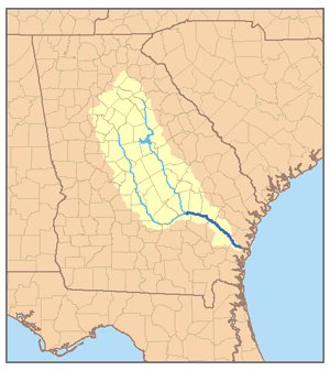
It’s a long, meandering river.  A vast wilderness, right smack-dab in the middle of the Georgia Coast. It's the largest undammed river on the Eastern Seaboard.  At 14,000 square miles, its watershed is the third largest river basin east of the Mississippi. Yet, it is contained entirely within the state of Georgia. The Nature Conservancy calls it one of “America’s Last Great Places” and the Western Hemisphere Shorebird Reserve Network has named it a Site of Regional Importance.  Some people call it “Georgia’s Little Amazon.”   You’ve probably never heard of it.  But if you live on the East Coast, there is a good chance you’ve driven over it. 


This place is the Altamaha River.


The Altamaha River watershed, including its two major tributaries, the Oconee and Ocmulgee Rivers (Source: Pfly, CC BY-SA 2.5 <https://creativecommons.org/licenses/by-sa/2.5>)


We have spent a lot of time with our students on the Altamaha and its estuary.  We’ve studied its fish and its water quality, from Doboy and Altamaha Sounds, upstream to the top of the delta.  And in our free time, we’ve explored its salt marshes, brackish marshes, and bottomland forests.  It is simply spectacular.  The most amazing thing is that you can spend an entire day on the water and scarcely see another boat.  There aren’t many navigable coastal wetlands in the U.S. where this is still true. 


Formed by the confluence of the Oconee and Ocmulgee Rivers, the Altamaha flows southeastward from central Georgia, reaching the Atlantic Coast between the towns of Darien and Brunswick.  For its entire 137-mile length, it is crossed by only 7 bridges: 5 road bridges and 2 railroad trestles. But one of those bridges is Interstate 95, the main north-south highway on the East Coast.  


The Altamaha supports the highest concentration of rare species of any river in Georgia; over 120 species of rare or endangered plants and animals, including 11 species of endangered mussles (7 of which are found nowhere else in the world). Other threatened and endangered species include the swallow-tailed kite, West Indian manatee, Atlantic sturgeon, and shortnose sturgeon (the Altamaha has the largest population of shortnose sturgeon south of Cheseapeake Bay).  Practically every species of bird that migrates along the Atlantic Flyway can be found in the Altamaha basin at some point in the year. 


Of course, the Altamaha is home to (almost) countless species of reptiles and amphibians, including A LOT of American Alligators. The vast, remote waters of its delta are also said to be home to “Altamaha-ha,” a mythical serpent whose description seems remarkably similar to that of the Loch Ness Monster.  Given the diversity of large critters who make their home here – which, in addition to those already mentioned, includes bottlenose dolphins, tarpon, gars, cobia, and many species of shark – it is not surprising that legends of such a Nessie-like "cryptid" creature abound. 


Not Altamaha-ha (AKA "Altie"), just a good'ole American alligator.  Gators are common here, especially in the the small creeks that crisscross the Altamaha Delta's brackish marsh. 

Loki on gator watch.


The reason that this great biodiversity persists is that there are large tracts of undisturbed wetlands encompassing several habitats, each hosting a distinct ecological community.  Starting upstream, the Altamaha’s tributaries run through long-leaf pine forests in Georgia’s Piedmont.  As you float along toward the coast, the flow of water slows, the river meanders, and its flood plain expands into bottomland hardwood forests and cypress swamps. At the upper threshold of the intertidal zone, just before the forest transitions into coastal marshes, the flood plain becomes tidal freshwater forested wetlands - TFFWs.  That’s right, it’s a forest that floods regularly at high tide.  Usually, it floods with freshwater but during big storms, it can be inundated with brackish water. Sea level rise is also causing the intertidal transition zone to move further inland, up the river. The salt marsh is marching inland along with it. Continuing downstream from the TFFW, you next encounter the brackish marsh, salt marsh, coastal sounds, the barrier islands, and finally, the ocean.  


Tidal freshwater forested wetland (TFFW) along the South Altamaha.


Brackish marsh surrounding General's Cut, a canal cutting more-or-less straight across the Altamaha Delta.  Before routes 17 and 95 were constructed, this was the primary way that people traveled between Brunswick and Darien.  Today, it's a pretty quiet stretch of water.  


An afternoon thunder storm in late June over the salt marsh that fringes Doboy Sound.


Looking out to sea from the crest of the primary dune at Nanny Goat Beach, Sapelo Island.


The Altamaha is a big river.  On average, it discharges about 100,000 gallons of water every second.  Driving over the Altamaha on Interstate 95, you would be forgiven for not noticing it, despite its enormous discharge.  Beginning just a few miles upstream from the point where the highway crosses, the main stem of the river branches repeatedly to form the complex network of smaller river channels and creeks of the Altamaha Delta.  As you cross each body of water, the signs on the highway say “Darien River,” “Butler River,” and “Champney River” (In addition to one that says “Altamaha River”).  But make no mistake, they are all branches of the Altamaha.  This river system conveys so much freshwater that it enters the ocean via two separate tidal inlets: Altamaha Sound and Doboy Sound.  


Screen capture from a Navionics chart showing the lower Altamaha River, the north end of St. Simons Island, Altamaha Sound, Wolf Island, Doboy Sound, the south end of Sapelo Island, and the Atlantic Ocean. Interstate 95 is the white line that crosses the entire delta from north to south. (https://webapp.navionics.com/)

The Altamaha Delta ecosystem has been studied intensely for over 20 years by scientists associated with the Georgia Coastal Ecosystems - Long Term Ecological Research Program, which is based at the University of Georgia Marine Institute on Sapelo Island. Funded by the National Science Foundation, this project involves dozens of faculty, graduate students, undergrads, and technicians from universities all over the country. It is one of the largest ecological research programs in the southeast U.S. The focus of the research is on long term environmental change. Many of the "fun facts" that we are providing here were established by this research program.

An incredible amount of land along the Altamaha has been set aside for conservation and recreation.  Almost the entire last 60 miles of the river is protected by a patchwork quilt of managed lands.

Protected lands along the entirety of the Altamaha (https://garivers.org/wp-content/uploads/2018/11/AltamahaRiverCanoeTrailMap2012ARP.jpg).

Managed lands in the lower Altamaha Watershed (https://insideradvantage.com/2017/10/27/georgia-continues-altamaha-river-conservancy/)

The town of Darien sits on a bluff overlooking the north side of the delta, and is home to Georgia’s largest commercial shrimp fishing fleet.  


F/V Grave Digger is a working shrimp boat that ties up at the docks next to Skipper's Fish Camp, on the Darien waterfront.  The bulk of the shrimp fleet ties up on the downstream side of the Rt. 17 bridge (background).

Darien is home port for the largest shrimp fleet in Georgia.


If you want to explore the Altamaha, the best way is by dinghy, kayak, or tour boat.  The water is navigable for larger boats pretty far upstream but the air draft of the Route 17 and 95 bridges is only 35 feet, and there are a lot of shoals and sandbars to dodge.  If your boat can fit under a 35’ bridge, one of the coolest anchorages and best hurricane holes in Georgia is just upstream of I-95, on the South Altamaha River. Unfortunately, Fulmar's mast is too tall to get there.  


The South Altamaha, which intersects the Atlantic Intracoastal Waterway (ICW) at marker 218.  The marina at Two-Way Fish Camp is just downstream (to the right) of the Route 17 bridge indicated by the orange and yellow line.  The hurricane hole mentioned in the text is indicated by the red and purple pins, just upstream of the blue and white diagonal line representing I-95 (https://webapp.navionics.com/).  


If your boat can't fit under a 35-foot bridge, you can anchor on the South Altamaha just downstream of the marina at Two-Way Fish Camp or get a dock space at Two-Way or at the the McIntosh County docks in Darien, on the Darien River (north side of the delta).  There are also boat ramps at Darien, on Champney Island, and at Two-Way Fish Camp.  From any of these locations, you can strike out in a small boat and explore some of the most breathtaking wilderness on the East Coast. The Georgia River Network has an app that gives information on public access points along the river. 

Is this a divine message?  Could this be our next cruising boat?  It's pretty common for cruising sailors to graduate to a trawler yacht once sailing becomes too much of a physical challenge.  But why have a trawler yacht when you can have a real trawler?

If you ever get the chance, check out the Altamaha River, Georgia's Little Amazon.  And if you can't get to the Georgia Coast, get out there and see the "Little Amazon" near you, whatever natural wonder that may be.