Thursday, January 11, 2024

2023 Cruising Highlights, Part II: Pamlico Sound to Chesapeake Bay

 This is part II of a post describing our favorite stops during our nearly year-long cruise along the East Coast. Part I covered our favorite places south of Pamlico Sound, NC. Part II picks up in Pamlico Sound and continues northward.


Our route through the Pamlico and Albemarle Sound region of North Carolina.  South River is at point 13, Oriental is near point 7, Hobucken is south of point 25, Washington is point 31, Ocracoke is point 39, and South Lake anchorage in the Alligator River National Wildlife Refuge is point 59.  


A clearer view without all those points obscuring the chart. 


Site of the former town of Lukens, on the east shore of the South River.


A dinghy adventure up a tributary creek that runs into the South River.


  • South River, NC (Anchor): Twenty five years ago, Damon did his dissertation research on the fish and bottlenose dolphins that inhabit the estuaries of North Carolina.  The South River was part of his study area.  It's a beautiful stretch of coastline; sparsely populated and surrounded by salt marsh and pine forest.  While we were anchored there, we spotted a large group of dolphins that included some of the same individuals that Damon studied as a graduate student all those years ago.  There's no real town here, nor any stores or facilities.  But there is a small boat dock and gravel boat ramp, which we were able to use.  On the east side of the South River, is the historic Lukens Cemetery, the only remnants of the defunct town of Lukens.  


The view from Oriental's waterfront park, looking out toward the mouth of the Neuse River and Pamlico Sound.  


The main road in the town of Oriental.  It floods pretty regularly.  You can see that the water is pretty even with the roadway.  Nobody would intentionally build a road, or a town, this low.  Of course, the water was lower (and the land was higher) when the town was founded. 


Water on that same street in Oriental, on a sunny, calm day.  If you look closely, you can see some small, brown fishies swimming near the upper left corner of the sewer grate.  They are  mummichogs.  When not swimming around in the streets, they can be found in salt marshes. 


The free shuttle that takes cruisers to the grocery store.  


The best chandlery ever, located about 50 yards from the waterfront in Oriental.


  • Oriental, NC (Dock: Oriental Marina):  The Albemarle & Pamlico Sound region of North Carolina is a fantastic area for cruising, but not many sailors have figured this out (which is one of its attractions). The little town of Oriental, on the north shore of the Neuse River estuary, is in the heart of this great cruising ground. Oriental describes itself as the “Sailing Capital of North Carolina,” and it ticks all the boxes for us.  Besides the typical restaurants and shops, Oriental really caters to cruisers.  The grocery store has a free shuttle that will pick you up at any of the local marinas.  With half a dozen marinas in town, there are plenty of marine services available: riggers, sail lofts, canvas makers, diesel mechanics, electronics shops, fiberglass repair…if you can name it, you’ll find it in the little town of Oriental.  And Oriental is home to our favorite chandlery, Inland Waterway Provision Company.  This store goes above and beyond to help cruisers and they know exactly what their customers need.  They were able to get spare parts for our engine delivered the next day, for free.  And they provide free loaner bikes for cruisers.  We stayed at the well-protected, fixed docks at the Oriental Marina. Among the marina's amenities are a tiki bar and swimming pool, just a few steps away from the dock.  The town of Oriental also has two free docks for transient cruisers, with room for 4 boats. Sadly, Oriental is also one of the places where the effects of rising waters are clearly evident. It's not uncommon to see fish swimming in the street...seriously. This wasn't the case 25 years ago when Damon was conducting his research in this region.


The dock at R.E. Mayo Seafood in Hobucken.  Trawl nets spread out to dry and to be mended are common at commercial fish docks. 


Fulmar on the dock at Hobucken's R.E. Mayo Seafood.  Notice the fishing boats in the background.


Loki loves commercial fish docks...there are delicious snacks just laying around everywhere.  This unfortunate pinfish was mummified.  It was the perfect pinfish jerky.  Boy was he mad that we wouldn't let him keep it. 


  • Hobucken, NC (Dock: R.E. Mayo Seafood):  This is not a marina, and it’s not luxurious, by any stretch.  It is a commercial dock for Hobucken’s fleet of large fishing vessels.  Dockage here is cheap and they sell seafood at wholesale prices.  We got overnight dockage, a pound of shrimp, and a couple grouper filets for $42!  The dock is just one long face dock, right on the ICW. So it’s easy in, easy out.  Besides selling seafood, they have a great marine supply store that caters to the fishing vessels.  So it’s a good place to stock up on parts and supplies.  There is literally nothing else in the area, besides mosquitos and stray cats, so it’s not the kind of place where you’d want to spend a lot of time.  But it’s a convenient stop, halfway between the Pamlico and Neuse Rivers, and a good departure point for heading to the Outer Banks, which lie on the opposite side of Pamlico Sound.  Because of its central location, we stopped in Hobucken three times during this cruise.   


The city docks in Washington, NC.  Fulmar is the second mast from the right.


  • Washington, NC (Dock: Washington Waterfront Docks):  We found North Carolina to be the most cruiser-friendly state, and “Little Washington” is legendary among cruisers for its hospitality.  Near the heart of this historic town, the municipal docks provide easy access to stores and restaurants of all types.  The city docks cater to cruisers, with inexpensive rates, free loaner bikes, cheap laundry facilities, and nice showers.  Most importantly, they have friendly, knowledgeable staff (who, by the way, carry dog treats in their golf carts, much to Loki’s enjoyment).  This also happens to be the home town of Pacific Seacraft Yachts, the company that built Fulmar.   Little Washington is fantastic, but it’s blazing hot in summer.  In fact, the extreme heat caused our inflatable paddle board to explode violently.  So after our stay here, we escaped the heat by heading east, down the Pamlico River and across the Sound to the Outer Banks.


Ocracoke Island has a rich maritime history.


Howard's Pub: for over 25 years it has been a favorite joint of ours on Ocracoke.


Silver Lake, Ocracoke's main harbor.


Loki: "Crab cakes and steaks?  Yes, please."

  • Ocracoke, NC (Dock: Anchorage Inn & Marina):  Ocracoke Island is a beach community that is part of North Carolina’s Outer Banks, which are the barrier islands that form the eastern boundary of Pamlico Sound.  Unlike the other Outer Banks communities, which are all accessible from the mainland by car, Ocracoke is only accessible by boat.  If you don’t have your own boat, you can take a ferry.  The added difficulty of getting to Ocracoke keeps it a little less crowded and a little less developed than the communities on the neighboring islands to the north.  Most of the Island is National Seashore (similar to a national park).  We stayed on a fixed dock at the Anchorage Inn & Marina, just feet away from an outdoor restaurant and swimming pool.  (You may be sensing a pattern.)  Ocracoke is not a great place to provision or to accomplish major boat projects, but the beaches are spectacular, and its temperature in the summer is about 10 degrees cooler than what you find on the west side of Pamlico Sound.  It also has great restaurants, including one of our all-time favorite beach bars, Howard’s Pub.


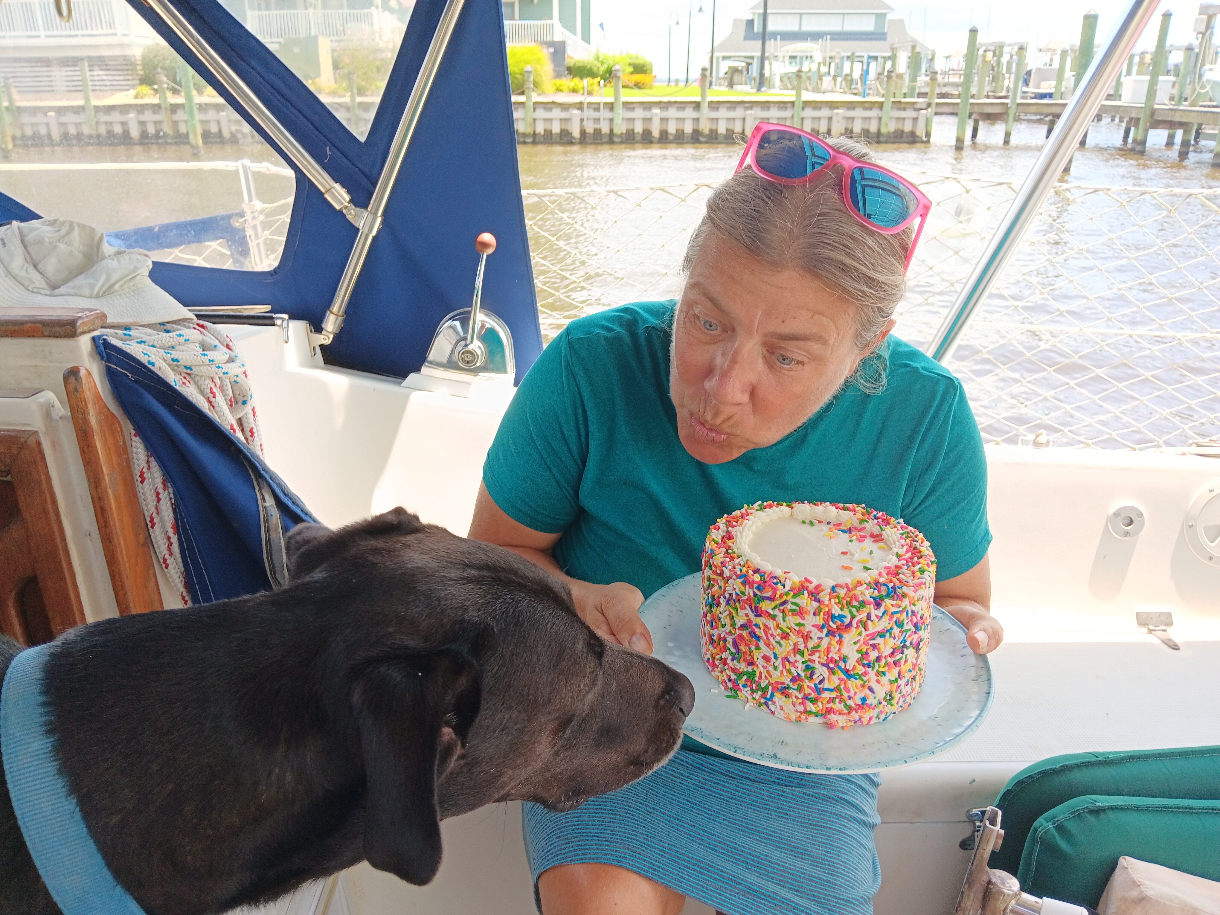
We celebrated Janet's birthday in Belhaven.  Who would have guessed that Loki loves cake. 


  • Belhaven, NC (Dock: Belhaven Marina):  Belhaven is a cute little town with less than 2,000 residents.  It’s on the Pungo River and feels like it’s at the edge of the known world.  The Mexican restaurant in town has great, inexpensive food and their margaritas come in a glass that’s bigger than your head.  The Belhaven Marina is one of the smallest marinas we visited and definitely one of the friendliest.  Despite its small size and reasonable price, they provided great service and had fantastic facilities.  The grocery store is a couple of miles away, so the marina provides a free, street-legal golf cart for their customers to run errands.  


  • South Lake/Alligator River, NC (Anchor):  The Alligator River National Wildlife Refuge is one of America's great wilderness areas.  It's the only place on the Atlantic coast where red wolves live.  It’s pretty far “out there,” so there aren’t any shoreside facilities.  But we found that we could get ashore by taking the dinghy up a narrow creek to where local crab fishermen keep their boats.  There was nothing there but a dirt road and a few small crab boats tied to shore.  But Loki isn’t too picky.  It wasn’t easy to find this little creek at 10:00 on a dark, overcast, misty night, even though we had been there in the daylight just a few hours earlier.  That’s just part of the fun of cruising.  This area near the mouth of the Alligator River and south shore of Albemarle Sound had the highest densities of crab pot buoys of our entire trip.  The crabbers avoided setting their gear in the main channel of the ICW but getting from the ICW to the anchorage required some careful maneuvering.   


At the free docks in Great Bridge, you get a front-row seat to watch the barges go by.


  • Great Bridge/Chesapeake, VA (Dock: Great Bridge Free Dock):  Great Bridge is at the north end of the Virginia Cut Canal, and is the gateway to Chesapeake Bay. There are two free docks just south of the Great Bridge Lock; one on either side of the drawbridge (which, believe it or not, is called the “Great Bridge Bridge”).  The docks are both located in public parks and are an easy walk to stores and restaurants.  We tied up to the bulkhead that lies between the lock and bridge.  Both of these free docks are right on the ICW, and they are long face docks, which makes arrival and departure quick & easy.  This area is very well protected from wave action and tidal currents, thanks to the lock.  There is quite a bit of commercial vessel traffic that passes through this stretch of the ICW.  It can be disconcerting to have 300-foot-long barges pass within 10 feet of your docked boat.  But you get used to it.  This is a not-to-be-missed stop on the ICW.  


Our route around the Chesapeake Bay.  Yorktown is just off the bottom of the chart, Urbanna is point 129, Reedville is 219, Solomons is west of 211, and Oxford is the northernmost point.


Looking north from the dock in Yorktown.  It's beautiful but that's a lot of open water, and it continues out into the Chesapeake.


  • Yorktown, VA (Dock: Riverwalk Landing Pier):  This is not a great place to provision or to work on boat projects.  There really aren’t any stores of any kind nearby.  But it is a great place to geek out on history.  There is  Historic Yorktown, the Yorktown Battlefield National Colonial Historic Park, the Revolutionary War Museum, the Waterman’s Museum, and a great little public beach, all within an easy walk of the dock.  And there are some very unusual geologic formations in this region that scientists call “hills.”  Having spent the last 7 years on the coastal plain of the Southeast U.S., we can’t remember the last time we encountered a hill.  The River Walk Landing public dock at York is pretty exposed to open water.  It’s not a great place to be during unsettled weather, but we had a great time there during a week of relatively calm conditions. 


Loki on the small barrier beach that protects Urbanna's harbor.


  • Urbanna, VA (Anchor and Dock: Urbanna Marina):  Urbanna is a great little town located about 10 miles up the Rappahannock River.  We stayed at anchor for several days here, then moved to a slip at the Urbanna Marina so we could fill our water tanks and do some boat chores before heading back out.  The anchorage at Urbanna is snug and it’s just a short ride to the public dinghy dock.  Restaurants, shops, and a grocery store were all within reasonable walking distance.  Marinas in the Chesapeake tend to be expensive and, yes, a bit pretentious.  Urbanna Marina is an exception.  The marina has very nice facilities but it is literally a mom & pop operation.  The owner is also the dock master, and he provided great service.  When we asked him if there was anywhere in town where we could get our propane tank filled, he apologized and said that there wasn’t any place close that could do it.  Because of this, he explained, that he was working on getting a propane filling station at the marina but it wouldn’t be operational until next season.  Then he said that he had to run some errands in the neighboring town that afternoon and could fill our tank while he was out.  So he took the tank with him, filled it, and brought it right back to our boat.  Now that’s service.  They also had free loaner bikes.


The smell of money.  One of the many menhaden purse seiners based in Reedville. 


The waterfront in Reedville.  There's not much freeboard on those docks, or on the surrounding land.


One of the many stately homes on Reedville's Main Street, known to locals as "Millionaire's Row."


  • Reedville, VA (Anchor):  Reedville is the menhaden fishing capital of the world, and the menhaden fishery is the largest fishery on the U.S. East Coast.  For over a century, these little fish have made Reedville a prosperous community, indicated by the Victorian mansions that line either side of the town’s main street, nicknamed “Millionaires’ Row.”   The harbor at Reedville is a complex network of relatively deep creeks, offering great protection from the weather.  One of the local restaurants has a dock that it makes available for free, even though the restaurant is only open on the weekends.  It’s a quiet, picturesque fishing town.  Cruisers just have to know not to anchor downwind from the fish processing plant or too close to the any of the commercial docks.  The menhaden fishing boats are enormous and there isn’t a lot of room to maneuver in the creeks.  


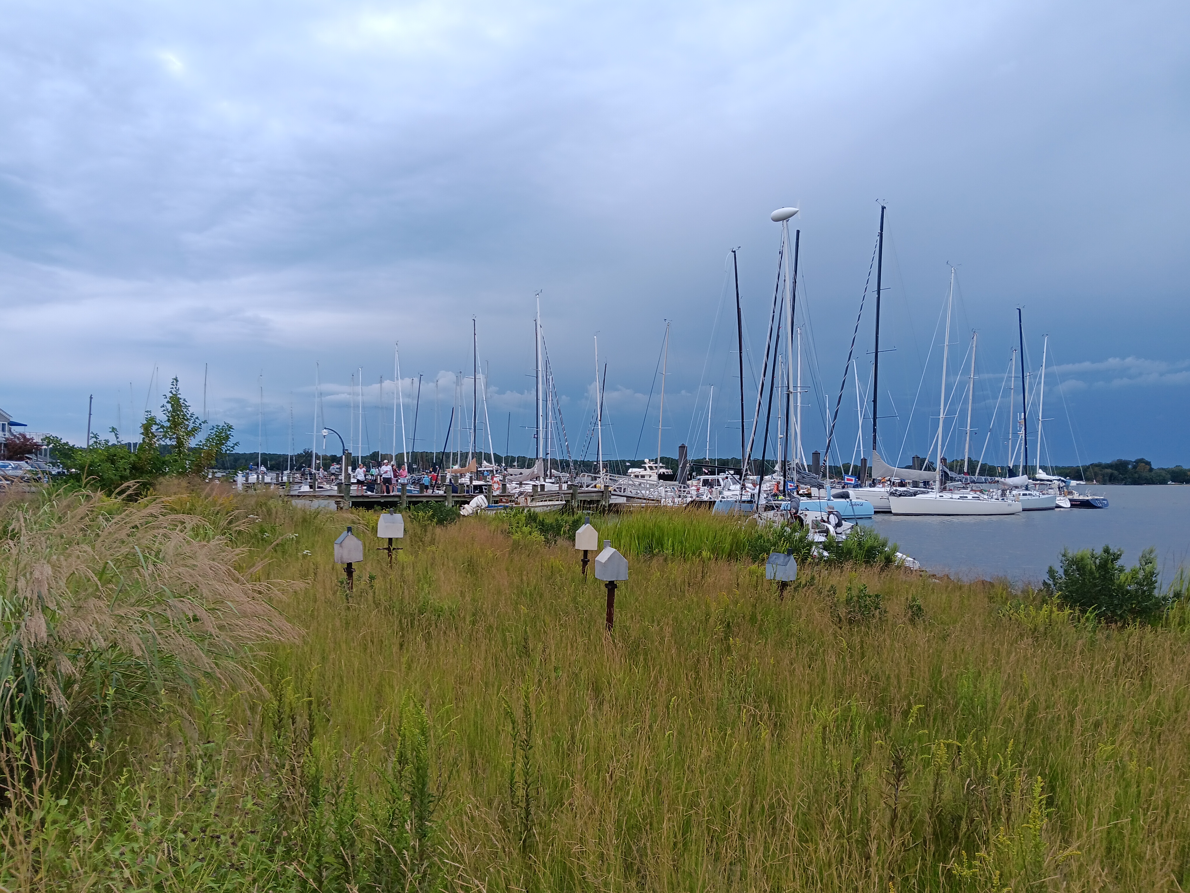
Crowd at the speed docking competition on Solomon's Island, put on by the Calvert County Watermen's Association.


Tripling up our mooring pennant in preparation for tropical storm Ophelia.


Dead calm during a blood red sunset over Solomons, as we wait for the arrival of tropical storm Ophelia.


  • Solomon’s Island, MD (Mooring: Zahnisers Safe Harbor Marina):  Solomon's Maryland is a sailing and fishing town. It's also home to the Cheseapeake Biological Laboratory; sort of the Woods Hole of Chesapeake Bay. The harbor at Solomon’s Island is large and well-protected, but its shoreline is highly developed.  Almost the entire shoreline is lined with marina docks, bulkheads, and private docks.  The mooring field operated by Zahnisers Safe Harbor Marina is extremely close to the docks.  We stayed for a total of about three weeks, during two separate stops.  For most of that time, we didn’t bother to use the outboard motor on our dinghy because we were so close to shore.  When the wind was blowing from a favorable direction, we’d compete to see who could row to the dinghy dock using the fewest number of strokes (Damon did it in 9 strokes).  Being close to shore is convenient.  But in a storm, there is such a thing as being a little too close for comfort, especially when that shoreline is ringed with docks.  The mooring fees here were the most expensive of our entire trip, comparable to the dockage rates at a lot of marinas.  Given the high rates that they charge, you’d expect the moorings to be in top condition.  Unfortunately, this was not the case.  One morning when we had returned to the boat after taking Loki for a walk, we noticed that the large trawler yacht that had been on the mooring just upwind of us, was now on a different mooring. It turned out that their mooring pennant had parted, in relatively moderate winds.  Fortunately, the owners of that boat were aboard and recognized the problem immediately.  They were able to start their engines and get the boat under control before they crashed into Fulmar.  We were very thankful for their quick action.  After hearing their story, we immediately tripled up the pennant on our mooring to be safe.  Two days later, we weathered a glancing blow from a tropical storm, without incident.  On the plus side, this marina did provide free bikes, shuttle van, and coffee (Damon can drink a lot of Joe, so this turned out to be quite a savings for us).  It also had a nice pool and outdoor bar (which we never used).  But the best thing about Zahnisers is that it is a Clean Marina, an official designation which means they have high environmental standards.  Among the requirements to maintain this standard, they have to maintain facilities for collecting used oil and antifreeze.  Oil recycling is pretty common (but not universal).  Collecting used antifreeze, however, is really rare.  Antifreeze is recyclable, but almost no marina or auto parts store accepts it. Disposing of it is a problem because it is toxic.  The last time we serviced our engine’s heat exchanger, it took us weeks to find a place that would accept the used antifreeze.  Because we knew Zahnisers would gladly take our used antifreeze, we decided to return there for a second visit to do some routine engine maintenance.  


The race fleet tied up at the Oxford Yacht Club, after finishing the Race to Oxford (from Annapolis).


  • Oxford, MD (Dock: Safe Harbor Oxford Marina):  Oxford is a quiet, little village on Maryland’s Eastern Shore, with a healthy mix of yachts and commercial fishing boats.  There is definitely a lot of money there.  Many of the elegant homes seemed like weekend retreats for people whose primary residences are near DC or Baltimore.  We were in Oxford during the 68th annual Race to Oxford, a sailing regatta that goes from Annapolis to Oxford and is sponsored by the U.S. Naval Academy.  The marina was quite nice.  Like most marinas around the Chesapeake, it seemed to cater primarily to local yacht owners rather than transient cruisers.  While we were tied up in Oxford, we experienced some of the strongest thunder storms of our entire trip.      


So those were some of the highlights from our 317 days of cruising the East Coast.  We hope to revisit these places again.  But for now, we need to concentrate on replenishing our cruising kitty!


2023 Cruising Highlights, Part I: Vero Beach, FL - Mile Hammock Bay, NC


Fulmar anchored near Jekyll Island, GA, on our first night of this cruise.


During the past year, we traveled almost 3,000 miles up and down the East Coast and visited a lot of great places.  We began and ended the trip in Brunswick, GA, first heading south in the Intracoastal Waterway (ICW) then turning around and going north when the weather became too hot. We made 88 stops that varied in duration from 1 to 22 nights.  Cruising by boat is the best way to see natural areas along the coast, as well as charming coastal towns.  Arriving via the water gives you a different perspective of the place and provides clues about its history.   

These 88 overnight stays were spent tied up to docks, secured to moorings, or anchored.  Generally, we prefer to anchor out.  There is nothing like being able to bring your floating home into the wilderness.  It’s also fun to be able to anchor close to a town; you can experience all the fun, touristy attractions, then retreat to the boat when the crowds begin to get on your nerves.  And anchoring is free, whereas a night at a dock can cost as much as a room in a high-end hotel. But because our canine crew member, Loki, needs to go ashore several times a day, we ended up staying in marinas much more often than we had planned.  Well over half of our overnight stops were at docks.  These ran the gamut from free, no-frills public docks to luxury marinas with all kinds of facilities and concierge services.  We tended to avoid the latter but splurged on occasion.  (BTW, We were hoping that Loki would learn to do his business on the boat.  An unbelievably high percentage of cruising boats have dogs aboard, and many of those dogs do learn to go on the boat.  But Loki showed no interest in the patch of artificial turf we provided, and we decided not to force the issue. A lot of sailors say you should just head out on an offshore passage and the dog will eventually go on the boat after 3 or 4 days. That just seems cruel.) 


Permanent moorings are maintained in the harbors of many coastal towns.  They’re far more common in the Northeast than in the South, but more and more communities in southern states are creating mooring fields as they try to deal with the epidemic of derelict boats anchored in their waters.  Moorings are sort of a compromise in price and convenience; they are cheaper than staying on a dock but they’re not free.  Mooring fields also tend to be located closer to the dinghy docks than are the anchorages (you can’t drop your anchor among the moorings).  And, in general, it's easier to secure your boat to, and depart from, a mooring than it is to do so at a dock.  Departing from a mooring is also much easier than is raising your anchor.  However, when you use your own anchor, you know the type of tackle that you have, its condition, and how it is deployed.  When you pick up a public mooring ball, you have no idea what’s holding that mooring in place.  You have to put your faith in the gear that has been provided and in the people who maintain it.  It’s prudent to have a healthy skepticism about the condition of public moorings. 


So we thought we’d share our thoughts on some of our favorite stops.  These locations are listed from south to north, Florida to Maryland. Without further adieu…


Central east coast of Florida.  Titusville is at the northern end of the Indian River Lagoon, northwest of Cape Canaveral.  Vero Beach is toward the south end of this chart. 


Three pocket cruisers rafted to one mooring at Vero Beach.


  • Vero Beach, FL (Mooring: Vero Beach Municipal Marina):  Vero is an upscale, touristy beach town.  It has a nice beach and plenty of great restaurants.  There is no shortage of ways to spend your money here.  It has some great attractions and amenities including an art museum, the best dog park on the entire ICW (according to Loki), and a good public bus system.  The municipal marina that manages the mooring field has a great dinghy dock and facilities, and the bus route has a stop right at the dinghy dock, making it easy to get provisions.   

The mooring field at Vero Beach is fantastic.  It’s a snug, little harbor surrounded by mangrove forests.  Exploring the vast network of mangrove creeks by dinghy or paddle board is a great way to spend the day here.  Thanks to its calm waters, the harbor master will typically have up to three boats raft together on each mooring.  Boats that are cruising together can often raft together, or you can meet new people by rafting alongside complete strangers. We spent a week or two rafted alongside our friends Ann and Elliot, who were cruising on their Tartan 37, Catherine.  


That's not a full moon; it's a Space-X rocket launch viewed from the dock in Titusville. 


  • Titusville, FL (Dock & Mooring: Titusville Municipal Marina):  Titusville is at the northern end of the Indian River Lagoon. We stayed in Titusville twice, on our way south and north.  Our first stay was at a slip and then on our second visit, we picked up a mooring.  Unlike most coastal towns in Florida, which are devoted exclusively to tourism, Titusville seems to be based more on reality, and less on fantasy.  There were vacationers and transplanted retirees in Titusville, but a lot of real people seem to live there, who have jobs and real lives.  This was good for us, because it meant that stores and services were readily available.  The marina was within walking distance to grocery, hardware, auto parts, and propane supply stores, and there was good public transportation.  The marina is surrounded by a large public park, which included a great dog park.  Titusville is also a great place to watch rocket launches from Cape Canaveral.  The marina staff were helpful, knowledgeable cruisers themselves, and the marina had a DIY workshop space.  The mooring field off of Titusville is a bit exposed to the weather and if you have one of the more distant moorings, like we did, it can be a long, wet dinghy ride to shore when the wind is blowing.  


Broughton Island, GA is in the Altamaha River Delta (left side of the chart).  All the land you see here is part of either the Altamaha Wildlife Management Area or the  Wolf Island National Wildlife Refuge.  


Sunrise over Broughton Island.


  • Broughton Island, GA (Anchor):  The Georgia coast has amazing natural areas.  It’s a 100-mile stretch of sparsely populated shoreline, with spectacular barrier islands, expansive salt marshes, and ancient cypress forests.  We only included our Broughton Island stop in this list because this region is so familiar to us, having lived here for 7 years.  We could have written entire posts about each of our stops in Georgia (Sapelo Island, Brunswick, Jekyll Island, and Cumberland Island) but decided to focus on just our stop at Broughton Island.  This spot on the South Branch of the Altamaha River is less than 5 miles from our former home in Darien, GA, as the crow flies.  Probably fewer than 1 percent of Georgia residents have ever heard of Broughton Island.  Hardly anyone visits, which is a shame.  It’s within the Altamaha Wildlife Management Area, which is alligator heaven.  Eastern diamondback rattlesnakes and water moccasins also make their homes here.  The waters surrounding the island are a nursery for large coastal sharks, including bull sharks.  And it’s not just the animals that may try to bite you; prickly pear cactuses, jumping cactuses, and sand spurs are quite common.  The Georgia Coast is a place that makes you aware that humans are still part of the natural food web.  And it’s wise to keep your pets on a short leash at all times.

While at anchor late at night near Broughton Island, we were startled awake by a deep, powerful growling sound coming from right next to the boat.  This was a roar that could be felt as much as heard. At first, we thought it was Loki growling, but he was still sound asleep (great watch dog that he is).  We got up and poked our heads outside and could just make out the shape of a very large gator swimming off our bow.  And then we noticed what seemed to be dozens of other gators scattered in all directions, bellowing in response.  We spend a lot of time in nature and have been fortunate enough to witness many of its wonders.  This was truly a special moment.  It was so captivating that neither of us had the presence of mind to make an audio recording.  Of course, we were extra vigilant during Loki’s pre-dawn dinghy ride to shore the next morning.  Pro tip: don’t linger near the water’s edge and never turn your back toward the water.


  • Lady’s Island, SC (Dock: Lady’s Island Marina):  Lady’s Island is directly across the ICW from Beaufort, SC, and the two are connected by a drawbridge.  We spent a few days here just before Thanksgiving, at first in a slip, then on the outside of a face dock.  The dockmaster was terrific.  Before we arrived, he emailed us a map of the marina that showed us exactly where our assigned slip was located and he provided information on the local tidal currents during our expected time of arrival.  Surprisingly few marinas do this for visiting boats.  The marina also has a DIY work space and a free loaner car.  So this is a great place to provision and to accomplish boat projects. We left Lady’s Island on Thanksgiving morning, thinking we were being very clever for doing this.  Most drawbridges open on a rigid schedule, which means that you often end up waiting for an opening.  But we knew that the Lady’s Island Bridge opened on-demand during holidays, so we shouldn’t have to wait.  Boy, were we surprised to find out that the bridge was closed for over two hours that morning for a turkey trot road race.  The captain of the tugboat pushing a 300-foot-long fuel barge was also surprised that the bridge wouldn’t be opening immediately.  With about a half-dozen other sailboats and this tug & barge, we waited for over an hour for the bridge to open.  Of course there was a very strong tidal current pushing us toward the bridge.  It wasn’t that big of a problem, but there were some tense moments trying to avoid all of the obstacles.  One of the golden rules of boating is to expect other boat operators to do unexpected things at inopportune moments.


This chart shows how the deep channel that used to go all the way to the steel mill has filled in with sediment (white is deep water, blue is shallow, and gold is land).  The anchorage is in the upper left of the chart.  Large commercial vessels used to be able to proceed directly to the stee mill by staying to the west of the island.  Now there isn't even enough water for our dinghy to make it through there.  The way into the anchorage is via that narrow channel that runs along the edge of Georgetown's waterfront.  


The view of anchorage from the waterfront boardwalk in Georgetown.  The steel mill and paper plant are in the background. 

  • Georgetown, SC (Anchor):  Georgetown is an attractive place with a nice waterfront, featuring several great restaurants along a boardwalk.  The anchorage is pretty popular; it’s very well protected and gives easy access to town.  Opposite the scenic waterfront is the hulking remnants of a shuttered steel mill, which gives the anchorage a bit of a “Mad Max” feel.  Having up-to-date depth surveys from the US Army Corps of Engineers is helpful here.  Since the steel mill closed, the main channel is no longer dredged for commercial vessels and it has shoaled dramatically.  Sailors looking at older charts will be surprised to find that there is less than a foot of water where the chart shows depths of over 30 feet.  But there is a “back door” entrance to the anchorage that goes along the town’s waterfront.  


Fulmar motoring up the Waccamaw River, with impenetrable cypress forests on both sides of the river.


The water is deep right up to the edge of the forest.  But if you get too close to the edge, you may thump a log or stump. 


  • Waccamaw River, SC (Anchor):  There are lots of great anchorages along the Waccamaw.  We anchored about a mile upstream of the ICW at Enterprise Landing.  This is in the Waccamaw River National Wildlife Refuge.  There is hardly any dry ground anywhere in this region; it’s all cypress forest with the ancient cypress trees growing right out of the water.  The trees provide excellent protection from the wind and habitat for countless birds.  We could have anchored much further up the river but we needed to stay within a couple miles of dry ground so that we could dinghy Loki ashore to stretch his legs.  One of the great things about this spot is that the water is fresh.  Saltwater is one of the most corrosive substances known to humankind.  Something fantastic happens to ocean sailors when they take their boats into freshwater: the little voice in the back of their heads that constantly reminds them: “Every piece of metal on this boat is rusting away,” finally shuts up.  We spent quite a bit of time in the dinghy, exploring the tributaries and side creeks of the Waccamaw, some of which were like tunnels under the forest canopy.  We had planned to spend more time there and to take the dinghy as far upstream as we could get.  But we discovered that the gas tank for the dinghy’s outboard had been contaminated with water, which became apparent when the carburetor clogged and the engine refused to run.  It turns out that water doesn’t combust very well.  It’s not a difficult problem to fix, but it’s a lot easier to work on an outboard on land rather than while leaning over the side of the boat. So we cut our stay short to deal with the dinghy motor, and hope to return to the Waccamaw again some day.  


The Osprey Marina in Socastee is great for a lot of things, but not for swimming.


We had to maneuver Fulmar around this 90-degree corner to get to our slip.  Notice how far out the outriggers from that blue sportfishing boat point toward the trees.  We had very little clearance for our mast and rigging.  But the water was still, the wind calm, and the shoreline soft.  


  • Socastee, SC (Dock: Osprey Marina):  Socastee is just a few miles south of Myrtle Beach, and these two places couldn’t be more different.  Myrtle Beach is the poster child for unrestrained coastal urban sprawl.  Socastee is a quiet, rural area.  The Osprey Marina is a small mom & pop operation located in a cypress forest.  The marina itself was built on what used to be a quarry of some sort.  It’s a great, big hole in the ground, connected to the ICW by a long, narrow canal dredged through the forest.  It’s a little unnerving the first time you go there; when you enter the canal, you can’t see the marina at the other end, the overhanging trees force you to stay right in the center of the canal (1-way traffic only), and once you have entered the canal there isn’t enough room to turn around if you had to.  When you reach the end of the canal, it opens up into a larger basin that is taken up almost entirely by the docks.  There doesn’t seem to be enough room to maneuver between the docks and shore, but the grassy shoreline plunges down into the water as a vertical wall, so you can lay your boat right up against the shore without fear of actually running aground.  This is an extremely well-protected spot; we waited out an early-season tropical depression in a slip here and barely noticed that the wind was blowing at all.  And the great thing about this marina is that the water here is fresh.  Spending time here got rid of a lot of the barnacles and other marine growth on our bottom, extending the time between bottom cleanings.  


A beautiful beach day at Carolina Beach.


Even with beautiful weather and normal tides, the ocean floods the streets of Carolina Beach (BTW, driving your vehicle through saltwater is a very, very bad idea...unless you're looking for an excuse to get a new one.)


It's a bad sign when marine creatures swim around your streets.  This is a cannonball jelly; the most favorite food of leatherback sea turtles, which is the largest reptile in the world. 


  • Carolina Beach, NC (Mooring: Town of Carolina Beach):  Carolina Beach is a honky-tonk beach town famous among East Coast surfers.  From the mooring field we had easy access to town and to the beach.  However, there are no marina facilities, so no showers or laundry.  These moorings were in the best condition of all the moorings we encountered on the ICW.  Every day, the harbor master would go around to the empty moorings and pull the pennants out of the water and place them on top of the ball to keep algae from growing on them.  That sort of attention to detail instills confidence in the security of the entire mooring system.  We saw evidence of sea level rise along our entire trip.  But Carolina Beach was one of the places where it was most obvious.  During a typical high tide, regardless of weather conditions or moon phase, the streets close to the harbor would flood with seawater.  We saw million-dollar, waterfront house lots for sale that had salt marsh plants growing all over them because they flooded regularly.      


Some people say that the anchor holding in Mile Hammock Bay isn't great.  We're  here to tell you that the holding is just fine, and this picture is proof.  That's what the anchor brought up from the bottom of the bay.  Our washdown pump was leaking so we put off cleaning up the mess until we got to a dock.  And that's what it looked like after we had already rinsed it down with buckets of water. 


  • Mile Hammock Bay, NC (Anchor):  We decided to stop at Mile Hammock Bay because there are few other options in the area.  It’s a long run from Carolina Beach to Swansboro, and it’s not a good idea to navigate the ICW at night, especially in the area around Brown's Inlet.  Mile Hammock Bay is within the Marine Corps Base Camp Lejeune.  So the water is open to the public but you’re not allowed to go ashore.  Armed MPs make this point abundantly clear.  This seemed like a bit of a problem for Loki.  So we weren’t expecting to have a lot of fun on this stop.  But we figured that once we were anchored, we could zip back down the ICW in the dinghy for a couple of miles to find a publicly accessible piece of land.  It turned out that as we arrived at the entrance to Mile Hammock Bay, we noticed a bunch of people, dogs and small boats on a beautiful patch of beach just a few hundred yards further north on the ICW.  Despite our low expectations, this proved to be a great overnight stopover for Loki.  He had a blast running around on the beach and we had fun at anchor watching the military aircraft, Marines, and Navy Seals training all around us.  The neighbors were a bit noisy at times but they stopped blowing things up by about 10:00 pm. 


Part II of this post will cover the cool places from Pamlico Sound to Chesapeake Bay.