These 88 overnight stays were spent tied up to docks, secured to moorings, or anchored. Generally, we prefer to anchor out. There is nothing like being able to bring your floating home into the wilderness. It’s also fun to be able to anchor close to a town; you can experience all the fun, touristy attractions, then retreat to the boat when the crowds begin to get on your nerves. And anchoring is free, whereas a night at a dock can cost as much as a room in a high-end hotel. But because our canine crew member, Loki, needs to go ashore several times a day, we ended up staying in marinas much more often than we had planned. Well over half of our overnight stops were at docks. These ran the gamut from free, no-frills public docks to luxury marinas with all kinds of facilities and concierge services. We tended to avoid the latter but splurged on occasion. (BTW, We were hoping that Loki would learn to do his business on the boat. An unbelievably high percentage of cruising boats have dogs aboard, and many of those dogs do learn to go on the boat. But Loki showed no interest in the patch of artificial turf we provided, and we decided not to force the issue. A lot of sailors say you should just head out on an offshore passage and the dog will eventually go on the boat after 3 or 4 days. That just seems cruel.)
Permanent moorings are maintained in the harbors of many coastal towns. They’re far more common in the Northeast than in the South, but more and more communities in southern states are creating mooring fields as they try to deal with the epidemic of derelict boats anchored in their waters. Moorings are sort of a compromise in price and convenience; they are cheaper than staying on a dock but they’re not free. Mooring fields also tend to be located closer to the dinghy docks than are the anchorages (you can’t drop your anchor among the moorings). And, in general, it's easier to secure your boat to, and depart from, a mooring than it is to do so at a dock. Departing from a mooring is also much easier than is raising your anchor. However, when you use your own anchor, you know the type of tackle that you have, its condition, and how it is deployed. When you pick up a public mooring ball, you have no idea what’s holding that mooring in place. You have to put your faith in the gear that has been provided and in the people who maintain it. It’s prudent to have a healthy skepticism about the condition of public moorings.
So we thought we’d share our thoughts on some of our favorite stops. These locations are listed from south to north, Florida to Maryland. Without further adieu…
 |
| Central east coast of Florida. Titusville is at the northern end of the Indian River Lagoon, northwest of Cape Canaveral. Vero Beach is toward the south end of this chart. |
 |
| Three pocket cruisers rafted to one mooring at Vero Beach. |
Vero Beach, FL (Mooring: Vero Beach Municipal Marina): Vero is an upscale, touristy beach town. It has a nice beach and plenty of great restaurants. There is no shortage of ways to spend your money here. It has some great attractions and amenities including an art museum, the best dog park on the entire ICW (according to Loki), and a good public bus system. The municipal marina that manages the mooring field has a great dinghy dock and facilities, and the bus route has a stop right at the dinghy dock, making it easy to get provisions.
The mooring field at Vero Beach is fantastic. It’s a snug, little harbor surrounded by mangrove forests. Exploring the vast network of mangrove creeks by dinghy or paddle board is a great way to spend the day here. Thanks to its calm waters, the harbor master will typically have up to three boats raft together on each mooring. Boats that are cruising together can often raft together, or you can meet new people by rafting alongside complete strangers. We spent a week or two rafted alongside our friends Ann and Elliot, who were cruising on their Tartan 37, Catherine.
 |
| That's not a full moon; it's a Space-X rocket launch viewed from the dock in Titusville. |
Titusville, FL (Dock & Mooring: Titusville Municipal Marina): Titusville is at the northern end of the Indian River Lagoon. We stayed in Titusville twice, on our way south and north. Our first stay was at a slip and then on our second visit, we picked up a mooring. Unlike most coastal towns in Florida, which are devoted exclusively to tourism, Titusville seems to be based more on reality, and less on fantasy. There were vacationers and transplanted retirees in Titusville, but a lot of real people seem to live there, who have jobs and real lives. This was good for us, because it meant that stores and services were readily available. The marina was within walking distance to grocery, hardware, auto parts, and propane supply stores, and there was good public transportation. The marina is surrounded by a large public park, which included a great dog park. Titusville is also a great place to watch rocket launches from Cape Canaveral. The marina staff were helpful, knowledgeable cruisers themselves, and the marina had a DIY workshop space. The mooring field off of Titusville is a bit exposed to the weather and if you have one of the more distant moorings, like we did, it can be a long, wet dinghy ride to shore when the wind is blowing.
 |
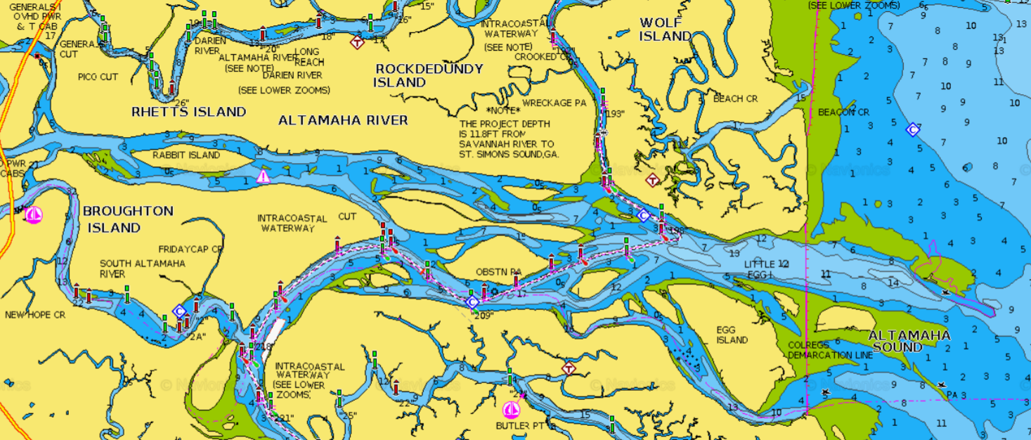
Broughton Island, GA is in the Altamaha River Delta (left side of the chart). All the land you see here is part of either the Altamaha Wildlife Management Area or the Wolf Island National Wildlife Refuge.
|
 |
| Sunrise over Broughton Island. |
Broughton Island, GA (Anchor): The Georgia coast has amazing natural areas. It’s a 100-mile stretch of sparsely populated shoreline, with spectacular barrier islands, expansive salt marshes, and ancient cypress forests. We only included our Broughton Island stop in this list because this region is so familiar to us, having lived here for 7 years. We could have written entire posts about each of our stops in Georgia (Sapelo Island, Brunswick, Jekyll Island, and Cumberland Island) but decided to focus on just our stop at Broughton Island. This spot on the South Branch of the Altamaha River is less than 5 miles from our former home in Darien, GA, as the crow flies. Probably fewer than 1 percent of Georgia residents have ever heard of Broughton Island. Hardly anyone visits, which is a shame. It’s within the Altamaha Wildlife Management Area, which is alligator heaven. Eastern diamondback rattlesnakes and water moccasins also make their homes here. The waters surrounding the island are a nursery for large coastal sharks, including bull sharks. And it’s not just the animals that may try to bite you; prickly pear cactuses, jumping cactuses, and sand spurs are quite common. The Georgia Coast is a place that makes you aware that humans are still part of the natural food web. And it’s wise to keep your pets on a short leash at all times.
While at anchor late at night near Broughton Island, we were startled awake by a deep, powerful growling sound coming from right next to the boat. This was a roar that could be felt as much as heard. At first, we thought it was Loki growling, but he was still sound asleep (great watch dog that he is). We got up and poked our heads outside and could just make out the shape of a very large gator swimming off our bow. And then we noticed what seemed to be dozens of other gators scattered in all directions, bellowing in response. We spend a lot of time in nature and have been fortunate enough to witness many of its wonders. This was truly a special moment. It was so captivating that neither of us had the presence of mind to make an audio recording. Of course, we were extra vigilant during Loki’s pre-dawn dinghy ride to shore the next morning. Pro tip: don’t linger near the water’s edge and never turn your back toward the water.
Lady’s Island, SC (Dock: Lady’s Island Marina): Lady’s Island is directly across the ICW from Beaufort, SC, and the two are connected by a drawbridge. We spent a few days here just before Thanksgiving, at first in a slip, then on the outside of a face dock. The dockmaster was terrific. Before we arrived, he emailed us a map of the marina that showed us exactly where our assigned slip was located and he provided information on the local tidal currents during our expected time of arrival. Surprisingly few marinas do this for visiting boats. The marina also has a DIY work space and a free loaner car. So this is a great place to provision and to accomplish boat projects. We left Lady’s Island on Thanksgiving morning, thinking we were being very clever for doing this. Most drawbridges open on a rigid schedule, which means that you often end up waiting for an opening. But we knew that the Lady’s Island Bridge opened on-demand during holidays, so we shouldn’t have to wait. Boy, were we surprised to find out that the bridge was closed for over two hours that morning for a turkey trot road race. The captain of the tugboat pushing a 300-foot-long fuel barge was also surprised that the bridge wouldn’t be opening immediately. With about a half-dozen other sailboats and this tug & barge, we waited for over an hour for the bridge to open. Of course there was a very strong tidal current pushing us toward the bridge. It wasn’t that big of a problem, but there were some tense moments trying to avoid all of the obstacles. One of the golden rules of boating is to expect other boat operators to do unexpected things at inopportune moments.
 |
| This chart shows how the deep channel that used to go all the way to the steel mill has filled in with sediment (white is deep water, blue is shallow, and gold is land). The anchorage is in the upper left of the chart. Large commercial vessels used to be able to proceed directly to the stee mill by staying to the west of the island. Now there isn't even enough water for our dinghy to make it through there. The way into the anchorage is via that narrow channel that runs along the edge of Georgetown's waterfront. |
 |
| The view of anchorage from the waterfront boardwalk in Georgetown. The steel mill and paper plant are in the background. |
Georgetown, SC (Anchor): Georgetown is an attractive place with a nice waterfront, featuring several great restaurants along a boardwalk. The anchorage is pretty popular; it’s very well protected and gives easy access to town. Opposite the scenic waterfront is the hulking remnants of a shuttered steel mill, which gives the anchorage a bit of a “Mad Max” feel. Having up-to-date depth surveys from the US Army Corps of Engineers is helpful here. Since the steel mill closed, the main channel is no longer dredged for commercial vessels and it has shoaled dramatically. Sailors looking at older charts will be surprised to find that there is less than a foot of water where the chart shows depths of over 30 feet. But there is a “back door” entrance to the anchorage that goes along the town’s waterfront.
 |
| Fulmar motoring up the Waccamaw River, with impenetrable cypress forests on both sides of the river. |
 |
| The water is deep right up to the edge of the forest. But if you get too close to the edge, you may thump a log or stump. |
Waccamaw River, SC (Anchor): There are lots of great anchorages along the Waccamaw. We anchored about a mile upstream of the ICW at Enterprise Landing. This is in the Waccamaw River National Wildlife Refuge. There is hardly any dry ground anywhere in this region; it’s all cypress forest with the ancient cypress trees growing right out of the water. The trees provide excellent protection from the wind and habitat for countless birds. We could have anchored much further up the river but we needed to stay within a couple miles of dry ground so that we could dinghy Loki ashore to stretch his legs. One of the great things about this spot is that the water is fresh. Saltwater is one of the most corrosive substances known to humankind. Something fantastic happens to ocean sailors when they take their boats into freshwater: the little voice in the back of their heads that constantly reminds them: “Every piece of metal on this boat is rusting away,” finally shuts up. We spent quite a bit of time in the dinghy, exploring the tributaries and side creeks of the Waccamaw, some of which were like tunnels under the forest canopy. We had planned to spend more time there and to take the dinghy as far upstream as we could get. But we discovered that the gas tank for the dinghy’s outboard had been contaminated with water, which became apparent when the carburetor clogged and the engine refused to run. It turns out that water doesn’t combust very well. It’s not a difficult problem to fix, but it’s a lot easier to work on an outboard on land rather than while leaning over the side of the boat. So we cut our stay short to deal with the dinghy motor, and hope to return to the Waccamaw again some day.
 |
| The Osprey Marina in Socastee is great for a lot of things, but not for swimming. |
 |
| We had to maneuver Fulmar around this 90-degree corner to get to our slip. Notice how far out the outriggers from that blue sportfishing boat point toward the trees. We had very little clearance for our mast and rigging. But the water was still, the wind calm, and the shoreline soft. |
Socastee, SC (Dock: Osprey Marina): Socastee is just a few miles south of Myrtle Beach, and these two places couldn’t be more different. Myrtle Beach is the poster child for unrestrained coastal urban sprawl. Socastee is a quiet, rural area. The Osprey Marina is a small mom & pop operation located in a cypress forest. The marina itself was built on what used to be a quarry of some sort. It’s a great, big hole in the ground, connected to the ICW by a long, narrow canal dredged through the forest. It’s a little unnerving the first time you go there; when you enter the canal, you can’t see the marina at the other end, the overhanging trees force you to stay right in the center of the canal (1-way traffic only), and once you have entered the canal there isn’t enough room to turn around if you had to. When you reach the end of the canal, it opens up into a larger basin that is taken up almost entirely by the docks. There doesn’t seem to be enough room to maneuver between the docks and shore, but the grassy shoreline plunges down into the water as a vertical wall, so you can lay your boat right up against the shore without fear of actually running aground. This is an extremely well-protected spot; we waited out an early-season tropical depression in a slip here and barely noticed that the wind was blowing at all. And the great thing about this marina is that the water here is fresh. Spending time here got rid of a lot of the barnacles and other marine growth on our bottom, extending the time between bottom cleanings.
 |
| A beautiful beach day at Carolina Beach. |
 |
| Even with beautiful weather and normal tides, the ocean floods the streets of Carolina Beach (BTW, driving your vehicle through saltwater is a very, very bad idea...unless you're looking for an excuse to get a new one.) |
 |
| It's a bad sign when marine creatures swim around your streets. This is a cannonball jelly; the most favorite food of leatherback sea turtles, which is the largest reptile in the world. |
Carolina Beach, NC (Mooring: Town of Carolina Beach): Carolina Beach is a honky-tonk beach town famous among East Coast surfers. From the mooring field we had easy access to town and to the beach. However, there are no marina facilities, so no showers or laundry. These moorings were in the best condition of all the moorings we encountered on the ICW. Every day, the harbor master would go around to the empty moorings and pull the pennants out of the water and place them on top of the ball to keep algae from growing on them. That sort of attention to detail instills confidence in the security of the entire mooring system. We saw evidence of sea level rise along our entire trip. But Carolina Beach was one of the places where it was most obvious. During a typical high tide, regardless of weather conditions or moon phase, the streets close to the harbor would flood with seawater. We saw million-dollar, waterfront house lots for sale that had salt marsh plants growing all over them because they flooded regularly.
 |
| Some people say that the anchor holding in Mile Hammock Bay isn't great. We're here to tell you that the holding is just fine, and this picture is proof. That's what the anchor brought up from the bottom of the bay. Our washdown pump was leaking so we put off cleaning up the mess until we got to a dock. And that's what it looked like after we had already rinsed it down with buckets of water. |
Mile Hammock Bay, NC (Anchor): We decided to stop at Mile Hammock Bay because there are few other options in the area. It’s a long run from Carolina Beach to Swansboro, and it’s not a good idea to navigate the ICW at night, especially in the area around Brown's Inlet. Mile Hammock Bay is within the Marine Corps Base Camp Lejeune. So the water is open to the public but you’re not allowed to go ashore. Armed MPs make this point abundantly clear. This seemed like a bit of a problem for Loki. So we weren’t expecting to have a lot of fun on this stop. But we figured that once we were anchored, we could zip back down the ICW in the dinghy for a couple of miles to find a publicly accessible piece of land. It turned out that as we arrived at the entrance to Mile Hammock Bay, we noticed a bunch of people, dogs and small boats on a beautiful patch of beach just a few hundred yards further north on the ICW. Despite our low expectations, this proved to be a great overnight stopover for Loki. He had a blast running around on the beach and we had fun at anchor watching the military aircraft, Marines, and Navy Seals training all around us. The neighbors were a bit noisy at times but they stopped blowing things up by about 10:00 pm.
Part II of this post will cover the cool places from Pamlico Sound to Chesapeake Bay. 


No comments:
Post a Comment